Design, Science and Technology
45.7K views | +0 today
Follow
Design, Science and Technology
#ideas #design #science #technology #inspiration #media #information
Your new post is loading...
Rescooped by Antonios Bouris from green streets
Scoop.it!

'Shadowless' Towers Proposed for London's Urban Fabric

'Shadowless' Towers Proposed for London's Urban Fabric | Design, Science and Technology | Scoop.it
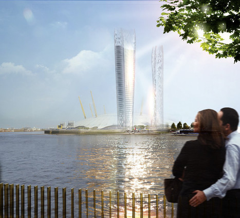
NBBJ proposes a set of "shadowless" towers for London's rapidly changing skyline.

Architects from the global firm NBBJ have designed what they call a “No Shadow Tower” for a site along the Thames River in London. The hypothetical scheme, developed in response to a call for ideas from the architecture think tank New London Architecture (NLA), offers one way to lessen the impact of tall buildings on the urban fabric surrounding them.


NBBJ’s proposed scheme has a similar goal to Jean Nouvel’s recently completed One Central Park complex in Sydney, which depends on a giant heliostat to illuminate a garden that would otherwise often be in shade. But NBBJ uses the geometry of the buildings themselves to mitigate their shadows. The two London towers subtly twist and flair, with floor plates that are slightly larger on the upper floors. Developed with parametric design, the configuration is intended to reflect sunlight from the south face of the taller tower into the plaza below. This arrangement would create what Coop describes as dynamic pools of light...


Via Lauren Moss
Lola Ripollés's curator insight, April 5, 2015 2:25 PM

Despite its name, the NBBJ proposal consists not of a single tower, but a pair of glass-clad skyscrapers—one about 50 stories tall and the other about 30 stories. Kidney-shaped in plan, with their concave elevations facing each other, the two buildings together define a plaza at the ground. This space captured NBBJ’s attention. “Although tall buildings have an impact on the skyline, their success or failure comes down to what occurs at the base,” says Christian Coop, design director of the firm’s London office.

 
Rescooped by Antonios Bouris from visual data
Scoop.it!

Mapping the 'Time Boundaries' of a City

Mapping the 'Time Boundaries' of a City | Design, Science and Technology | Scoop.it
An EU-funded project is building platforms to detect patterns in how people use urban spaces.


Maps don't typically convey time very well. They're static snapshots of a moment in history. A handful of animated maps that do a good job combining time and space using either transit data or geo-tagged social-media hits.

Now a new project, called Geographies of Time, is trying to do something similar with a more typical two-dimensional map. The effort is part of a broader EU-funded projects called UrbanSensing that's building platforms to detect patterns in how people use urban spaces.


Via Lauren Moss
luiy's curator insight, November 28, 2013 6:21 AM

Giorgia Lupi, the Ph.D. researcher at Milan Politecnico behind the project, began with Milan. Using tens of thousands of geo-tagged tweets, she and colleagues divided the map of the city into a fine-grained grid. The tweets were then divided into eight three-hour time intervals (from midnight to 3 a.m., 3 a.m. to 6 a.m., etc.). And the boxes in the grid were digitally colored based on the time window when Twitter was locally most active.

nuria font-casaseca's curator insight, April 24, 2014 9:21 AM

Les ciutats i els temps: com ens movem per la ciutat en funció de l'hora i el dia.