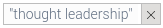

We could take human error out of the redistricting process entirely. Why don't we?
Get Started for FREE
Sign up with Facebook Sign up with X
I don't have a Facebook or a X account


 Your new post is loading...
 Your new post is loading...
Your new post is loading...
We could take human error out of the redistricting process entirely. Why don't we? 

Madison Murphy's curator insight,
May 16, 2017 2:34 PM
The Computer Programmer looks at gerrymandering in a different way by drawing boundary lines on his map and then comparing to show you the difference. This relates to the classroom by showing how gerrymandering draws lines of states but is illegal. This still exists and is bigger in political parties.

Mr Mac's curator insight,
June 13, 2017 10:23 AM
Unit 1 - regions, GIS, Unit 4 - districts, gerrymandering (please note, saying "solved" might be a stretch as any districting will have to work on some form of bias)
Sign up to comment
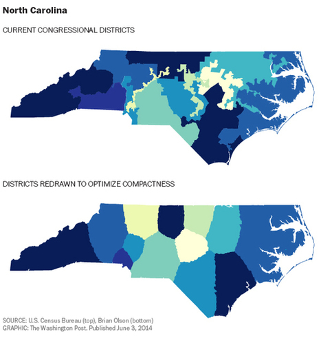
A step-by-step tutorial on how to create an interactive map with Visme, a free online infographic and presentation tool.

António Leça Domingues's curator insight,
December 19, 2016 6:44 AM
Criar um mapa interativo com Visme.

Bart van Maanen's curator insight,
December 19, 2016 10:02 AM
Mooie tool om een kaart van data te voorzien.
There is a proposal for a new Advanced Placement course in Geographic Information Science and Technology (AP GIS&T). All U.S. high schools, colleges, and universities are invited to review the proposal by visiting www.apgist.org. AP GIS&T is designed to introduce high school students to the fundamentals of geographic information science and applications of powerful geospatial technologies for spatial analysis and problem solving. The AP GIS&T course proposal has attracted broad support from prominent scientific and educational organizations. For AP GIS&T to become a reality, the AAG needs to collect attestations from 250 U.S. high schools that confirm they have the interest and capacity to offer the course. Similar assurances are needed from 100 colleges and universities that they would be willing to offer some form of credit to students who demonstrate proficiency on the AP GIS&T exam. High school principals and academic department chairpersons are invited to consider adding their institution to the list of AP GIS&T supporters by completing the brief attestation form at www.apgist.org. Please consider submitting an attestation by October 1, 2016. Have questions about AP GIS&T? Contact the AAG at ap_gist@aag.org. Via Mike Busarello's Digital Storybooks
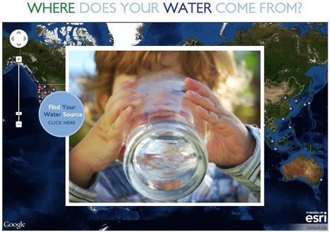
This interactive map documents where 443 million people around the world get there water (although the United States data is by far the most extensive). Most people can't answer this question. A recent poll by The Nature Conservancy discoverd that 77% of Americans (not on private well water) don't know where their water comes from, they just drink it. This link has videos, infographics and suggestions to promote cleaner water. This is also a fabulous example of an embedded map using ArcGIS Online to share geospatial data with a wider audience.
Tags: GIS, water, fluvial, environment, ESRI, pollution, development, consumption, resources, mapping, environment depend, cartography, geospatial. Via GTANSW & ACT

"Most of us are familiar with digital maps on our phones or computers. We think nothing of using these devices when finding directions to an unfamiliar place but what about when want to dig deeper? Thanks to some groundbreaking technology called augmented reality, our digital maps could be undergoing a revolution, changing how we find and discover the world around us." Via Fernando Gil

Join our FREE GIS Day World Record mapping event taking place during Geography Awareness week (Nov 17th -21nd 2014, video with more details). With a local to global perspective, we want students to map their thoughts and feeling about their local area.
They can add their data to a global map that is shared with the world. Help us achieve our goal of having 100,000 students take part globally. The event will provide great opportunities for:
Using the latest GIS technologySpatial thinkingData analysis with GISMap designConnecting students with their peers worldwide Tags: mapping, GIS, K12, ESRI, geospatial, edtech.
Via Mike Busarello's Digital Storybooks
|

Today, to the southeast of Block Island, there are five new structures rising from the ocean. These are the towers of the Block Island Wind Farm (BIWF), the first offshore wind energy installation in the United States. The turbines will generate 30 megawatts of energy; providing electricity to 17,000 households on Block Island and coastal Rhode Island (McCann, 2016), and replacing the diesel generators that previously powered New Shoreham. The turbines are on schedule to begin turning in November 2016 once commissioning is complete.
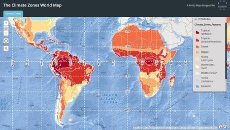
"Obsessed as we are with cartography we in Staridas Geography perceive any aspect of the actual 3D World as a constant opportunity for another pretty map creation!" Via Alex Smiga

GTANSW & ACT's curator insight,
August 19, 2016 7:47 PM
Great map to discuss global distribution of biomes and links to climate 
Sally Egan's curator insight,
August 21, 2016 6:24 PM
Fun way for students to learn about the diverse climates around the world, by selecting a location on the map students are shown the climatic data of the selected place.

War, sectarian violence, and famine have forced more than 50 million people from their homes—the largest number of displaced people since World War II.
Skuuppilehdet's insight:
Here are two excellent ESRI StoryMaps about the Syrian refugee crisis; these are two very good examples of a great web maps.
Tags: GIS, ESRI, mapping, cartography, geospatial, edtech, Syria, political, refugees.

Mr. D's Social Studies Classroom's curator insight,
March 2, 2016 5:34 PM
Here are two excellent ESRI StoryMaps about the Syrian refugee crisis; these are two very good examples of a great web maps. 'The Uprooted' (focused more on Syria).Epicenter of a Deepening Refugee Crisis (puts Syria into larger global patterns).
Tags: GIS, ESRI, mapping, cartography, geospatial, edtech, Syria, political, refugees. 
malbert's curator insight,
March 4, 2016 1:30 AM
Here are two excellent ESRI StoryMaps about the Syrian refugee crisis; these are two very good examples of a great web maps. 'The Uprooted' (focused more on Syria).Epicenter of a Deepening Refugee Crisis (puts Syria into larger global patterns).
Tags: GIS, ESRI, mapping, cartography, geospatial, edtech, Syria, political, refugees. 
Rachel Stutzman's curator insight,
March 11, 2016 10:28 AM
Here are two excellent ESRI StoryMaps about the Syrian refugee crisis; these are two very good examples of a great web maps. 'The Uprooted' (focused more on Syria).Epicenter of a Deepening Refugee Crisis (puts Syria into larger global patterns).
Tags: GIS, ESRI, mapping, cartography, geospatial, edtech, Syria, political, refugees.
A billion people worldwide live in slums, largely invisible to city services and governments — but not to satellites. Via Dawn Haas Tache

John Blunnie's curator insight,
July 28, 2013 1:11 PM
Great how tech and globalization can help represed people in other countries. 
Meagan Harpin's curator insight,
October 6, 2013 5:07 PM
The slum-mapping movement began in India almost a decade ago and migrated to africa, the idea of this is to make slums a reality to people who have never set foot in one before. The maps can be used in court to stop evictions or simply to raise awarance. I think this idea is on the right track of what needs to be done. These people need help and so many people incuding the governement pretend they arent their but with these maps as proof they can no longer do that. 
Elizabeth Bitgood's curator insight,
March 19, 2014 10:24 AM
Slums and squatter settlements are a problem that a lot of the developing world has to deal with. The unsafe and unsanitary buildings cause headaches and problems for the leaders of the cities they surround. This story is hopeful in that the city did manage to bring a water line out to get clean water to the people living in this area. Perhaps this will lead to a better quality of life of the inhabitants of this particular slum. Also the project of mapping such areas can be a useful tool for city planners to better regulate these areas and help the people that live there.,

The City of Melbourne maintains more than 70,000 trees. This website enables you to explore this dataset and some of the challenges facing Melbourne’s Urban Forest. Via Joanne Wegener
|