Research and publish the best content.
Get Started for FREE
Sign up with Facebook Sign up with X
I don't have a Facebook or a X account
Already have an account: Login

Into the Driver's Seat
454.7K views |
+5 today
Building learners' independence through thoughtful technology use
Curated by
Jim Lerman
 Your new post is loading...
 Your new post is loading...
Your new post is loading...
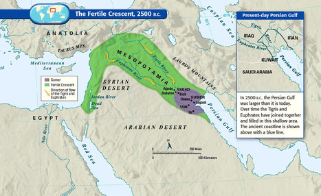
These maps are crucial for understanding the region's history, its present, and some of the most important stories there today. 

Alex Vielman's curator insight,
November 23, 2015 3:17 PM
Maps like the ones posted in this article, really helps people to understand and break down deeply of understanding the entire region as a whole. Visualization is very important in geography when trying to understand the region people are talking about. this region as goes down to the Mesopotamia Era. It is important to know, how the culture was in this area to how it differentiated during the Ottoman Empire. During the first couple of maps, we can begin to see the division of the entire region. As you go on, we begin to notice the divisions between people, religion, language between states and in-states. There is so much information to know about the Middle East region and it may be even harder to understand due to the tons of changes and separations, but it is important to understand these divisions like the Sunni's and the Shi'ites in order to fully explain the development and the current situations that are occurring in this region as we speak. 
Matt Ramsdell's curator insight,
December 7, 2015 5:18 PM
These 40 maps are a very interesting way of showing how people have traveled around and moved about the Earth from the time of the fertile crescent era to the people of today. It shows us the paths that people have taken to move to a new location. How they used the Meditteranean Sea to move from one side to the other. It also shows how the Tigris and Euphrates came together to form a smaller area of the Persian gulf. This led to smalled economic growth because now there is less land for imports and exports. 
Kelvis Hernandez's curator insight,
December 12, 2018 10:49 PM
Being able to explain any region in just 40 maps is a very bold claim. While no one would be able to do this Vox was able to make a very interesting set of historically, culturally, and politically themed visualizations of this continuously changing part of the world. Some maps show the borders of an empire past, others discuss the many ethnic groups that call the region their home, and yet another discusses the importance of oil and who has it. |
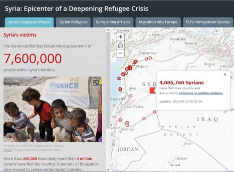
Thousands of refugees, many of them fleeing the brutal conflict in Syria, are streaming across Europe in search of safety and security.

Tanya Townsend's curator insight,
November 23, 2015 11:42 AM
This story map is a great visual of the current refugee crisis. This would be a helpful aid in describing the geographical barriers refugees face and how it affects them. For example the map shows where highest concentrations of deaths occur, naturally it is in the ocean. The ocean is a barrier for fleeing refugees. Think about how different landscapes and land forms can affect refugees available paths to flee |